C'est une histoire qui commence en 2003, celle d'un pilote de simulateur de vol sur PC qui passe son brevet de pilote (PPL) et qui remplit sa boite à souvenirs.
Il y a quelques jours, je mettais à disposition une modeste correction du terrain de KMYF Montgomery Field. Je voulais corriger les noms des taxiways et des points d'arrêt. Et aussi, voir si je pouvais supprimer quelques balisages disgracieux. 3 ou 4 soirées plus tard, j'ai amélioré 10 x plus de choses sur cette scène.
C'est petit, c'est léger et ça se place simplement dans le dossier Community. Si ça ne plait pas, il suffit de l'effacer du dossier Community. Et hop.
Que les choses soient clairs : je ne suis pas un développeur de scène pour Flight Simulator. J'ai juste re-utilisé les objets disponibles dans la bibliothèque et grâce à quelques tutos sur Internet, j'ai joué au Lego. J'ai aussi juste re-utilisé la texture Bing intégrée et sous jacente qui ne reflète pas exactement les dernières modifications de taxiways (G1, E, M) ou le nouveau bâtiment de Crown Air. C'est donc un entre-deux. C'est plutôt fidèle sur les taxiways et panneaux (il m'en manque peu) et ça "ressemble de loin" pour des bâtiments que j'ai ajoutés ou remplacés. Un peu Canada Dry.
Je me suis complètement pris au jeu du Scenery Editor, l'outil intégré dans MSFS, qui permet visuellement et très facilement de placer des objets sur la scène. Et de voir le résultat presque immédiatement.
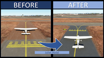
Mise à jour de tous les taxiways et panneaux en accord avec l'image Bing intégrée dans MSFS.
Ajouts des runup manquants sur Bravo 28L et Alpha 28R (et F/H 10R)
Affichage de l'image Bing au sol à certains endroits (Transient ramp, Marv Golden, zone ouest).
Remplacement de bâtiments iconiques comme le FBO Gibbs, Case Machado et la petite zone commerciale avec les restaurants et le pilot shop Marv Golden.
Nouveaux bâtiments autour de la tour de contrôle, l'helipad SDFD... et le bateau ?!
Toute la zone ouest comporte maintenant bien plus de bâtiments et hangars et retrouve son taxiway Kilo avec Sorby.
Toute la zone à au sud-est a été revue. Il manquait beaucoup de hangars et j'ai refait pas mal de marquages au sol.
Des voitures, des containers, des poubelles, quelques lampadaires, un palmier, quelques marshallers et des personnages sont posés de ci de là. Il y a même le lecteur de badge pour ouvrir le portail de Gibbs ;)
Des petites scénettes sur le parking Gibbs et au FBO que je vous laisse découvrir.
Tout cela est très amusant à faire. Et j'espère que ceux qui téléchargerons la scène y prendront du plaisir Je suis sûr qu'il y a plein d'imperfections. N'hésitez pas à partager vos commentaires.
Les Farwest'iens de 2019 se sont retrouvés dimanche dernier à Toussus-Le-Noble et nous n'avons pas résisté à refaire la photo prise à Las Vegas. Mais le froid glacial a calmé nos ardeurs ;)
The default Montgomery Field KMYF airport is great... but requires improvement: most taxiways and signs are inaccurate, some taxi blue lights obstruct movements, buildings are missing, there are windsocks everywhere... etc. Here's my first updated airport. Thanks so much to all the simmers who appreciate and supports our passion and encourage me to make the scenery. If you liked it, please write a comment!
To download the free file, go to flightsim.to: https://flightsim.to/file/5856/montgomery-gibbs-exec-airport-taxiway-fix-and-many-more
New taxiway names. C, A, H, G1, M, E are misplaced or non-existent in the stock MSFS version. They are updated in this scenery and are similar the official airport ground chart (for example via Airnav: https://www.airnav.com/airport/KMYF)
New taxiway signs : all signs have been reviewed and updated (see Caution)
A single windsock at the right place.
Extra bonus (it wasn't the initial project)
Missing buildings have been added according to the Bing Map photorealistic texture
The underlying default texture is resize and now reveal iconic locations: business area with FSDO and Marv's Golden, Casa Machado, west side of airport (to be continued), Gibbs FBO and more to come if you enjoy this first step.
How to install?
Unzip the file into your Community folder. Once installed go to KMYF as usual, the scenery is overlayed over the existing default one.
Caution
It's my first airport update. Don't expect high quality payware content. I'm totally new to the MSFS Scenery Editor mode. Feel free to comment and share any mistakes to improve this first work. I'm a member of a flying club at Montgomery Field (Plus One Flyers) but I leave in France.I fly at San Diego several times per year but my real experience of certain areas is null or very limited. For example, I never went (in real) in the west side at L, G. I have a lot of video material (check my Youtube channel) but I lack of shots at location I never went. If you have updates and picture valuable to update this scenery, feel free to contact me.
Limitations
This airport's update contains only stock objects. No handmade texture or 3D objects have been designed, because It's far beyond my design skill ;) Don't expect signs on buildings to be accurate. They give a feeling of "it looks like what we have in real". The Bing Map ground photorealist texture is not up to date. For example some ground markings, the old Crown Air building, G1 taxiway are wrong compare to today. This scenery is a mix between the date of the Bing texture and the today's real world.
After updating all the taxiways, which were the main initial objectve, I started to play with the MSFS scenery editor and enhanced other aeras. It's just a first try and play. Fences are not accuratly positioned. More to come if simmers are pleased with this first result! Let me know!
Known issues
Some red marked hold shorts do not appeared or are wider than in real. It's a SDK limitation.
All the perimeter fences are not yet in place and there are obviously a lot of security issue ;)
Some blue lights have been totally removed to clear the taxiway path. Unfortunately I didn't succeed in putting some at the right place. SDK limitation?
There's a lot of cars and trucks (even buses) moving around. I don't know yet how to limit/remove them. Any idea?
Tools used: ADE Beta 12 for MSFS to generate the initial .xml file, then everything is generated with the included MSFS SDK editor. Thank you to Antoine D. and Manuel G. for their Beta tests.
All the best for next year 2021 to all the blog readers. As for the holidays greetings, the above screen shot is taken from Microsoft Flight Simulator. Here at Santa Monica landing runway 21.
This MSFS Bush Trip offers you all the legs of real VFR flights we flew in May 2019 onboard a Cessna 172. It's a loop in California, Nevada and Arizona: from San Diego to Los Angeles, Monterey, Mojave, Las Vegas, Grand Canyon, Monument Valley, Marble Canyon, Sedona, Big Bear, Oceano and some others. Try to fly it as much as we did in VFR by following VFR charts but most of all enjoy the sightseeing.
MSFS Bush Trips are long VFR flights focused on sightseeing. It's ready-to-use: you are lined-up and just have to follow the nav log. MSFS Bush(1) Trips are simple multiple legs trips proposed to fly in sequence. Each leg start with a description of your route + destination airport and landmarks to overfly. In this FW19 Bush Trip, waypoints are a mix of Point of Interest (Hollywood Sign, Grand Canyon, LAX...) and radio navigation aids (VOR).
What is Farwest'19?
"Farwest" is a generic name of real flight trips organized by friends. Started in 2008, we usually depart from San Diego and fly VFR during 1 or 2 weeks, everywhere up to Canada and more. They were something like 15 Farwest so far. Most of the time, we enjoy flying in California, Nevada and Arizona. The "Farwest'19" (a.k.a FW19) took place in April-May 2019 with one Cessna 172 and a Piper PA28: four french friends private pilots just wanted to have fun in unbelievable landscapes.
Where this FW19 Bush Trip will fly me ?
San Diego Montgomery field to Bakersfield via LAX
Bakersfield to Monterey
Monterey to Mojave
Mojave to Las Vegas, NV via Edwards AFB
Las Vegas to Page, AZ via the Hoover Dam and the Grand Canyon (VFR corridor)
Page to Monument Valley
Monument Valley to Marble Canyon
Marble Canyon to Sedona
Sedona to Twentynine Palms
Twentynine Palms to Big Bear
Big Bear to San Luis Obispo
San Luis Obispo to Oceano
Oceano to Kern Valley
Kern Valley to Zamperini/Torrance via Hollywood Sign and Los Angeles international
Yes! Only 2 airports weren't in our FW19 but they were in several previous Farwest: Catalina KAVX and McCarran KLAS (during FW19, we landed at Henderson (KHND). I though it brings more fun to add these regular FarWest destinations. Some routes like the overhead of Edwards AFB weren't possible in 2019 but we succeed to get this clearance in previous Farwest. The real plane is a steam gauges Cessna 172 registered N4975F. Beside these, it's 100% what we were lucky to fly. Enjoy as much as we enjoyed.
Tip&Tricks: Auto-pilot and refuel
You can use the C172 autopilot and let electronic follow the route for you. It's a good way to enjoy the landscape and look outside instead of watching the PFD/MFD ;)
I suggest you bind a key to "Repair and Refuel" to avoid running out of Avgas ;)
Limitations
No altitude are set in the nav log due to Little Nav Map Flight Plan capabilities. There's no way to set altitude for each legs but some indications are available in each legs.
There is no ATC available. It's a limitation of the Bush Trip MSFS concept.
As soon as you stop your plane, the legs stop and... congratulations! In MSFS you can stop on the runway or just after vacated. It's up to you. But then you have finished the leg. In real world, another journey starts: find a parking slot for the plane and most of the time find the way to the FBO and fuel
This bush trip package use the Cessna 172 G1000 to be compatible with all MSFS version from standard to Premium Deluxe. See the below FAQ to change your plane.
The magenta line is not display on the G1000 MFD even if the full route is loaded. Because it would be too much helpful
Do you recommend any extra MSFS scenery?
The mission can be played with a stock MSFS, but you can improve your experience with these add-ons:
FSPM VFR Map by scelt to have a more detailed map in flight : click here.
My own San Diego Gibbs Exec Montgomery Field (KMYF) fix : click here.
FAQ
Where is my Community folder?
Microsoft Store: C:\Users\[Your Name]\AppData\Local\Packages\ Microsoft.FlightSimulator_8wekyb3d8bbwe\LocalCache\Packages\
Steam: C:\Users\[Your User Name]\AppData\Local\Packages\
Custom: where you select to install MSFS during the installation process. For example, mine is on H:\FS2020
How can I restart a leg? Delete your saved flight located here : C:\Users\<your Name>\AppData\Local\Packages\Microsoft.FlightSimulator_8wekyb3d8bbwe\LocalState\MISSIONS
How can I change the weather/time when starting a new leg ? The only way is to modify manually saved files during your progress:
Shut down MSFS
Open the 2 files FARWEST2019-MISSION_SAVE.FLT and FARWEST2019-MISSION_SAVE_0001.FLT from your Activities folder. + If you have the AUTOSAVE folder, also open the file FARWEST2019-MISSION_AUTOSAVE.FLT
In all your open .flt files, change the Weather section to only include these two items
[Weather]
UseLiveWeather=True
WeatherCanBeLive=True
Can I use another plane? Follow (at your own risks) instruction in the MSFS official forum. Keep in mind that it requires edition a .FTL file and after changing it you have to start the bush trip from the beginning. Maybe in a futur version I'll propose the classic C172 available in MSFS with the N4975F Replica texture from Marc "Flying V" Hardouin.
Do you have a Skyvector Flight Plan available? A simplified version (without all the POI's) is available here.
Grand Canyon VFR chart: in leg#5 (Vegas to Page) and leg#8 (Marble to Sedona) where can I find the Grand Canyon VFR chart with the SFRA and corridor's routes (for e.g. Fossil corridor) ? Go to Skyvector and select the Grand Canyon VFR.